
Maps are a central part of our experience of the fantasy genre: “No Tour of Fantasyland is complete without one,” wrote Diana Wynne Jones in The Tough Guide to Fantasyland; fantasy maps “are only much noticed when they’re absent,” notes The Encyclopedia of Fantasy. It’s easy to forget that maps are also found in science fiction. They don’t turn up as frequently, nor are they expected to, and we don’t talk about them or think about them nearly as often. But they do exist. I’ve been writing about fantasy maps for years, and even I didn’t give science fiction maps the same consideration at least until 2014, when during a presentation about fantasy maps at Readercon, I had to extemporize in response to a question about science fiction maps. My off-the-cuff response led me to look into where and how maps are used in science fiction, and from there to write this article on the subject.
I’ve argued elsewhere, particularly in my posts at Tor.com, that fantasy maps have a distinct and consistent style, a visual language that is frequently imitated—because fantasy maps signal the kind of fantasy novel they belong to, they not only tend to look like other fantasy maps, they need to do so—but rarely interrogated. That default style is not a simple pastiche of medieval or early modern maps; rather, it’s a surviving remnant of the pictorial map and children’s book illustration traditions of the mid-twentieth century. Science fiction maps also belong to that pictorial map tradition, and the original medium is similar: ink printed on paper, limited in detail and resolution by paper quality and the size of a book’s page. Some similarities in style are inevitable, though it is surprising how many science fiction maps are dead ringers for fantasy maps. That’s something we’ll explore in a moment.
At a functional level, maps in science fiction may not signify genre in the way that fantasy maps do, but they do have one purpose in common: to help the reader navigate a strange and unfamiliar setting. A key difference in science fiction is that those strange and unfamiliar settings are far more diverse. Fantasy worlds are designed with a much more limited palette. They are, in a fantasy context, familiar, and that familiarity is often the point; a fantasy map is in many ways a portal to familiar strangeness. Science fiction worlds can be far stranger, and that strangeness often means that the reader needs some help to encompass them.
Planetary Maps
That said, world maps, or rather planetary maps, remain a frequently seen form of science fiction mapping. Planetary maps are by no means ubiquitous or obligatory in sf: there are plenty of sf novels set on another planet that do not bother to map the planet, and there are plenty of novels where a map might have helped. Where they do appear, they can do so in interesting and unexpected ways.
For one thing, it’s notable how often maps of science fictional planets adopt the distinctive style of fantasy maps. The best-known example is, of course, Anne McCaffrey’s Pern. Bob Porter’s iconic map, which accompanied the main books from Dragonflight (1968) to Dragonsdawn (1988), adopts many elements of the default fantasy map style: oblique hill signs, shaded coastlines, labels that use script lettering, and an ornate compass rose. Rafael Palacio’s maps of Majipoor on the endpapers of Robert Silverberg’s Valentine Pontifex (1983) are also very much in that style: the oblique perspective, shaded hill signs and forests, and choice of lettering are typical of fantasy maps, and the larger-scale maps are more illustrations than map. Now, both Pern and Majipoor are science fiction settings with a strong fantasy flavor. They’re not science fantasy per se (at least by some definitions of the term) but science fiction that happens to have the thematic resonances and worldbuilding ethos of epic fantasy. Adopting the default fantasy map style, therefore, has a certain logic to it.
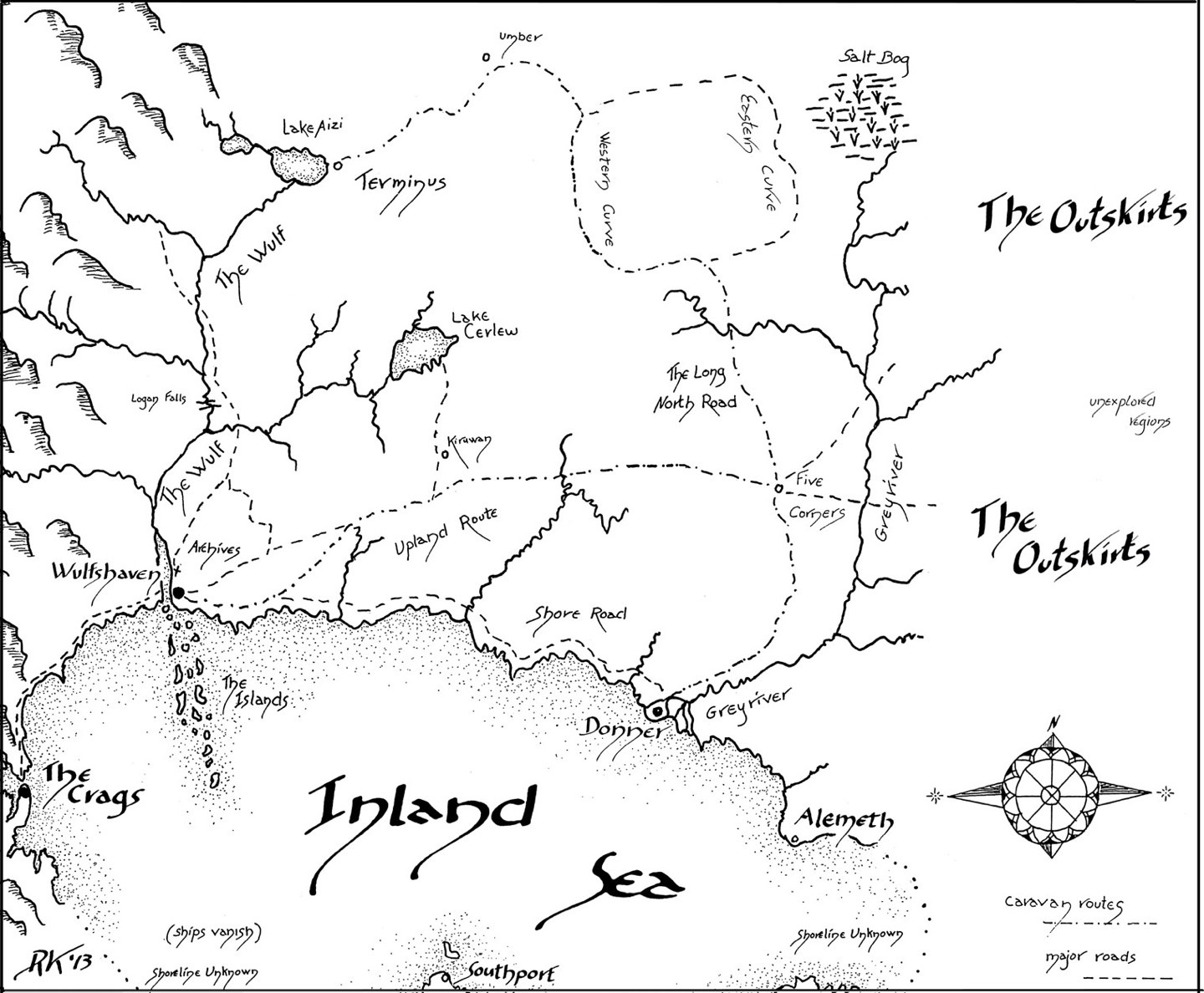
That logic is explicit in the maps in Rosemary Kirstein’s Steerswoman novels, whose characters see their science-fictional world through a fantasy lens: technology is magic; aliens are monsters and demons. The maps accompanying these books are meant to be the work product of a fantasy character trying to understand a science-fictional world: as the series progresses, each book’s map reveals the additional discoveries made in the previous book. The maps also follow the default fantasy map style to the letter—which Kirstein told me was a deliberate choice.
And then we sometimes find fantasy-style maps accompanying science fiction with no fantasy elements whatsoever. Hunter’s Run, the 2008 novel of alien contact by George R. R. Martin, Gardner Dozois, and Daniel Abraham, is not fantasy-flavored science fiction, but its map, drawn by Andrew Ashton, follows the default fantasy style: oblique hill signs, shaded coastlines, italic text, even a stylized (though science-fictiony) compass rose. The fact that Hunter’s Run has a map at all—most novels like it would have gone without—is likely for a simple reason: Dozois and Martin drew one during the story’s initial plotting (Dozois et al., 250), so it was available. The fact that it follows the fantasy style may simply be because there are a lot more fantasy cartographers out there than nonfantasy cartographers: Jeffrey Ward’s maps for Kim Stanley Robinson’s Antarctica (1998), for example, use fantasy map elements; Ward also drew the maps for George R. R. Martin’s A Dance with Dragons (2011), where the style was not so out of character. It’s as though the style, once established and in hand, was simply applied to science fiction.
But not every planetary map adopts the fantasy map style. Those that don’t are more likely to adopt the conventions of scientific and cartographic mapmaking and use routine map elements that almost never appear in fantasy maps such as a latitude/longitude grid or an actual map projection. In other words, these science fiction maps look more like modern-day maps than illustrations—maps that might have accompanied a work of nonfiction about the planet. And like real-world maps, they can embed more information than the strictly geographical.
Dorothy de Fontaine’s map of Arrakis in Frank Herbert’s Dune (1965) is, like Porter’s map of Pern, another classic and instantly recognizable science fiction map. It’s also unusual in ways that cannot be anything but deliberate. For one, it uses an azimuthal equidistant projection focused on Arrakis’s north pole. Longitude is not marked: there is no prime meridian. The only parallel of latitude marked is 60 degrees north—the equivalent of the southern border of Canada’s Yukon and Northwest Territories and roughly the latitude of Oslo, Helsinki, and Saint Petersburg—and there is not much on the map beyond that line. This is both significant and revealing: most of the planet is still unmapped, unknown, and off-limits—at least to its colonizers. (Here be sandworms.) Civilization, at least as the outworlders consider it, is limited to a small area around the north pole; as the story unfolds, there are interesting things going on past the edges of an explicitly colonial map.
In Kim Stanley Robinson’s Mars trilogy, each book includes a map of Mars in a cylindrical projection that stretches toward the poles; areas north and south of the 65th parallels are cut off. (A few detail and polar projection maps are sprinkled through the text of the books.) The maps are consistent in terms of coverage, grid lines, and projection—it helps that Mars is a real place, with known geographical features—but the maps for each book in the trilogy differ in their other particulars. In Red Mars (1993) the map is dominated by terrain; in Green Mars (1994) there is less detail, allowing the human settlements to be more prominent; and in Blue Mars (1996) the effects of terraforming—oceans and canals—appear on the map. Like Kirstein’s Steerswoman maps, the maps of the Mars trilogy tell a story in their changes.
Hemispheric maps also appear in science fiction, though without gridlines it’s impossible to tell whether the projection is orthographic or stereographic. The maps of C. J. Cherryh’s planet of Cyteen from the eponymous novel (1988) are of this kind. So are the maps of the moon of Medea in Medea: Harlan’s World (1985): drawn by Diane Duane, they include both geographic and heat poles, as well as the terminator—key geodetic features of a tidally locked world. In this case the basic configuration of Medea—how the planet works—is far more critical to understanding than the details of its geography: the maps are accordingly small, the coastlines and continents difficult to make out.
Some science fiction maps do the opposite and focus in closer. The maps accompanying Tobias S. Buckell’s Crystal Rain (2006), also by Jeffrey Ward, don’t show the entire planet of Nanagada, just the peninsula where the action takes place. Alexis Walser’s maps for The Legacy of Heorot, the 1987 novel by Larry Niven, Jerry Pournelle, and Steven Barnes, take things even further. The map of the planet is in an inset of the first map. The island where the action takes place, highlighted in the inset, is the subject. The second map shows the colony. The third and fourth maps show individual settlements, the scale growing larger with each map. This is a bit excessive—the third and fourth maps include tool sheds, wine cellars and dog runs—but Niven-Pournelle collaborations tend to come with a lot of what Gérard Genette called paratexts (Ekman, 20-21)—lists of characters, maps, appendices—that are not strictly necessary to the story (or at least to the reader), so it’s not exactly off-brand for them.
Maps of Non-Planetary Structures
A second category of maps is unique to science fiction: maps of nonplanetary structures. Artificial habitats, spaceships, and megastructures—anything with an unusual structure or layout that could be hard for the reader to visualize. In these cases, a map or diagram can help, though it’s not always necessary for that map to be detailed. Like the maps of Medea, it can suffice to show the gross outline or shape—the concept of the structure—because that’s all the reader really needs. Imagine if a globe’s main purpose were not to show the positions of seas, landforms, and countries but to demonstrate the concept of a round planet to an audience having difficulty visualizing it.
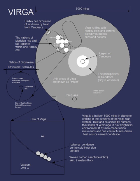
At the smaller end of the scale, science fiction set aboard a large spaceship may come with a map or diagram of that ship. Peter Watts is fond of including such maps though they’re not strictly essential for an understanding of the text: Echopraxia (2014) and The Freeze-Frame Revolution (2018) include diagrams of their respective ships, the latter complete with gravity gradients; while Blindsight (2006) didn’t include a similar map, one is available in interactive form on the author’s web site. At a few orders of magnitude greater in size, we have in Karl Schroeder’s Virga series a zero-gravity air balloon 5,000 miles across that is heated and lit by fusion-powered micro-suns inside. A single diagram, heavily annotated, introduces this setting in the third through fifth books of this series: Pirate Sun (2008), The Sunless Countries (2009) and Ashes of Candesce (2012). It’s notable that the first two books in Schroeder’s series appear to have done without the diagram; the setting was explained and explored in text.
This was also the case in the most famous example of a nonplanetary megastructure: Larry Niven’s Ringworld (1970), which introduced the Ringworld without the aid of an accompanying map or diagram. The task of depicting the structure was taken up by the cover art, at least in most editions; otherwise the concept was slowly introduced to the characters and the reader through dialogue and description in the text—and whatever else can be said about Ringworld, it’s a tour de force of this kind of explanatory exposition. The maps and diagrams came later: in Niven’s 1974 Analog article “Bigger Than Worlds” and in the second Ringworld novel, The Ringworld Engineers (1980), which includes a map by Diane Duane that focused on the small (for Ringworld values of small) portion of the Ringworld visited by the characters.
Most nonplanetary structures are more difficult to grasp intuitively than a ring around a sun. Nor are all of them artificial in origin. Niven’s Integral Trees duology is set in the habitable part of a gas torus surrounding a neutron star: a natural setting but one that might take some explaining. The Integral Trees (1984) has five pages of maps, each zooming in closer than the last, showing the astronomical position of the neutron star to its parent sun, the layout of the gas torus, and the structure of an integral tree. John Varley’s Titan (1979) also has multiple maps of the artificial being on which the action takes place: there’s a diagram of the entire Stanford torus to give us a sense of what it looks like, a detail showing the relationship between the spokes and the interior surface, and a cylindrical map of a portion of that interior.
Sometimes, though, a map can reveal too much, as in another Niven-Pournelle collaboration, The Gripping Hand (1993). Its map helpfully labels an important change in the region that proves to be an important plot point, which leads Justin Alexander to urge readers to avoid the map: “That thing is a cesspool of spoilers. And not in a ‘well, now we know where they’re going’ way, but in a ‘they just told us what Rosebud is’ kind of way. Unless you’re the type of crazy person who likes reading the last page of a mystery first, steer clear of the map.” But John Clute calls that same map “absolutely essential for any reader who wants to understand the physical relationship” among the various locations: in the U.K. edition, published under the title of The Moat Around Murcheson’s Eye, the maps are omitted. “The endpapers are blank. The tale is undecipherable” (Clute, 25-26). The Gripping Hand goes further than the usual fantasy novel: most fantasy novels can be read and understood without referring to the map, however essential the map’s presence may be seen to be. This may be a case where Niven and Pournelle’s fondness for paratexts has made them no longer para.
Maps of Interplanetary and Interstellar Civilizations
A third category of maps is probably the most plentiful kind in science fiction: maps of interplanetary and interstellar civilizations. If the first category is about mapping unfamiliar territories, and the second about mapping unfamiliar shapes, this category is about unfamiliar relationships: where one world exists in relation to its neighbors. That neighborhood could be interplanetary or interstellar; there are examples of each.
Interplanetary maps, bounded within a single solar system, are less common, possibly because a solar system is easy for science fiction audiences to visualize. It is sufficient to know that the action moves from the third planet to a moon orbiting the fifth planet. Only when the orbits and relationships are complicated, unintuitive and critical to the story that it becomes necessary to map them, as in the case of Medea, The Integral Trees, and The Gripping Hand: those orbits and relationships need explaining, and maps are part of the explanation.
Two examples of complicated solar systems come from television. Both Firefly (2002) and Battlestar Galactica (2004-2009) feature multiple-star solar systems where habitable planets orbit every sun. In both cases this was a worldbuilding decision that enabled travel between a dozen or more inhabited worlds within reasonable distances. On-screen, this situation is taken as a given; maps aren’t part of the televised narrative. But maps have been published after the fact: the creative studio Quantum Mechanix released licensed, official maps of both franchises. The maps are similar in design: photorealistic two-dimensional models—orreries on paper—with insets that allow for increased detail or a wider perspective as needed. Each looks like a National Geographic astronomical map from another part of the universe. They’re lovely. But they’re literally afterthoughts: they were made public after the shows were broadcast. If a map is a necessary part of understanding a complex interplanetary setting, neither of these shows makes the case for it: the geometry of the solar systems was not televised.
Maps of interstellar civilizations, on the other hand, are a commonplace of space operas and hard sf. They’re usually done in one of three ways:
First, as a simple representation of a galactic wheel. In Vernor Vinge’s A Fire Upon the Deep (1992), Elissa Mitchell’s map provides edge-on and top-down views of our galaxy that show out the boundaries of the various zones (but, crucially, without explaining them), with an inset showing some of the locations important to the story. It’s low on extraneous detail, and it serves the same function as other conceptual sf maps. Another example—to return to media sf for a moment—is Star Wars, whose maps, whether in the movies (the holographic map in The Force Awakens) or in related tie-in media, are invariably representations of the galactic wheel. These maps provide the big picture—a general sense of what’s happening on a galactic scale—but not much else.
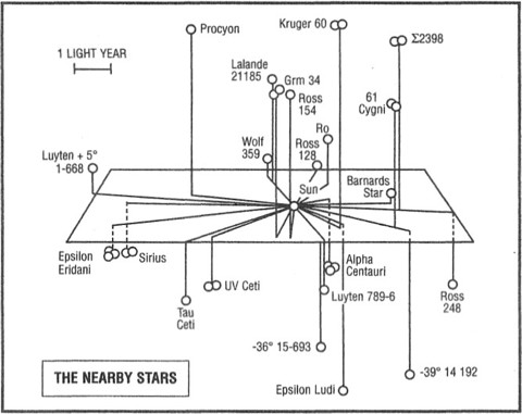
Second, as a grid map of local star systems. Maps like these suffer from the problem of representing three-dimensional space on a two-dimensional grid, a problem sufficient enough for James Davis Nicoll to opine in the context of role-playing games that “[t]here are reasons why maps are generally left out, and who notices an absence? […] The problem is twofold: there are a lot of stars in the galaxy, and at least on the small scales typical of most games, they are arrayed in all three dimensions.” Nevertheless, there are times when these maps are not left out; they appear when the story makes use of real stars whose positions can be plotted in space. Examples include maps for Gregory Benford’s Across the Sea of Suns (1984) and Gordon R. Dickson’s Childe Cycle. The flaw in such maps is when they emulate real-world celestial maps, which are always from Earth’s point of view; travelers between worlds on a map would not be able to use such a map. The map for Dickson’s Final Encyclopedia (1984) exemplifies this problem: set on a curved grid and derived from a celestial map (it includes degrees of right ascension and declination), it is clearly from Earth’s perspective, but also, bafflingly, includes Sol on what has become an impossible map. The map for Across the Sea of Suns, on the other hand, addresses this problem by placing stars above or below the map plane, which is centered on Sol.
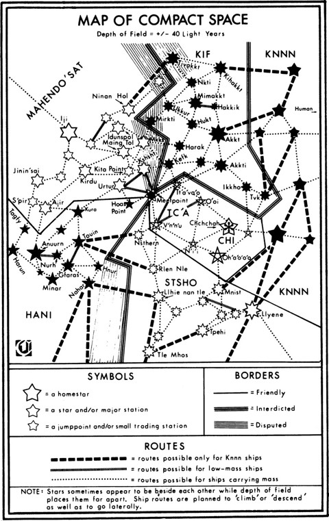
And third, as a network diagram showing connections between star systems. This method gets used in books about interstellar civilizations that travel between worlds using jump points or wormhole connections. Examples include Lois McMaster Bujold’s Vorkosigan Saga, where interstellar travel is along a wormhole network with limited connections between planets (Barrayar, for example, is connected to the rest of the network by only a single wormhole route), as well as Buckell’s Ragamuffin (2007), C. J. Cherryh’s Alliance-Union Universe, and David Weber’s Honorverse. An interesting exception that uses real star systems and normal space travel is the network of pre-FTL routes John Barnes sketched out for the future history of his Thousand Cultures books. The routes were determined by the maximum amount of time a sleeper ship could spend in transit.
These maps have a great deal in common with diagrammatic transit maps that show the network without reference to the physical world: the most famous example is Harry Beck’s now-iconic London Tube map. With diagrammatic transit maps, the exact distances between stations aren’t important: what’s important is being able to see how every line in the network relates to all of the others and how to get from one station on one line to another station on another line. In other words, what’s important are the connections. The same is true of network maps of star systems: they describe a form of transportation that is about travelling along the network with limited transfer points rather than direct point-to-point travel. The positions of these systems in space are irrelevant—which is convenient for a map on a two-dimensional page.
Conclusion
This has been only a preliminary outline with examples that may prove unrepresentative: the maps cited are based on what I had available in my own collection (which is not biased in favor of the sort of hard sf that comes with maps) as well as responses to a pair of queries on social media in July 2014. (Yes, this took me a while.) No doubt there are shockingly obvious examples I’ve missed that will immediately suggest themselves to the reader; I look forward to hearing about them. The point at this stage was not to be comprehensive but to set out some ideas about the kinds of maps found in science fiction.
From the examples explored here, we can discern several functions science fiction maps can perform on behalf of both text and reader. Maps may have a thematic purpose as in the case of maps of Pern or Majipoor in that their style signals a science fantasy environment, the use of fantasy reading protocols, and a text of likely interest to fantasy readers. They may have a storytelling purpose as with the maps from Dune, the Steerswoman series, and the Mars trilogy: the maps separate the known from the unknown, the transformed from the untouched, the colonized from the indigenous. Or they may have a conceptual purpose by giving the reader a big-picture understanding of structures, solar systems, networks, or empires.
It’s possible to draw from this that maps’ appearance in science fiction is limited to settings unfamiliar or complex enough to require some explanation: other worlds, unusual structures, interstellar civilizations with complex networks of trade and travel. But it also appears that some maps were included simply because they were created during production: in a field where paratexts run rampant; where collaborative authors produce glossaries, lists, and maps to keep everything straight; and where authors can include a hundred-footnote technical appendix at the end of a novel (as Peter Watts did), it’s easy to see how existing material can be included simply because it exists.
In other words, whether a science fiction novel comes with a map is subject to a much different calculation from whether a fantasy novel does. Absent the fantasy requirement to signal genre (i.e., “this is the kind of fantasy novel that comes with a map”), the decision to include a map in a science fiction novel—and which map to include—may be more idiosyncratic.
(This article has been edited slightly since its first publication.)
Works Cited
Maps Consulted (with Mapmaker Credit Where Known)
Planetary Maps: Tobias S. Buckell, Crystal Rain (Tor, 2006); map by Jeffrey Ward. C. J. Cherryh, Cyteen (1988; Warner, 1995); maps not credited. Harlan Ellison, ed., Medea: Harlan’s World (Bantam, 1985); map by Diane Duane. Frank Herbert, Dune (1965; Ace, 1999); map by Dorothy de Fontaine. Rosemary Kirstein, The Steerswoman’s Road (Del Rey, 2003), The Lost Steersman (Del Rey, 2003) and The Language of Power (Del Rey, 2004); maps by the author. George R. R. Martin, Gardner Dozois and Daniel Abraham, Hunter’s Run (HarperCollins, 2008); map by Andrew Ashton. Anne McCaffrey, Dragonflight (Ballantine, 1968); map by Bob Porter. McCaffrey, Dragonsong (1976; Bantam, 1977); map by Laura Lydecker. McCaffrey, The Skies of Pern (Del Rey, 2001); map by Mapping Specialists Ltd. Larry Niven, Jerry Pournelle and Steven Barnes, The Legacy of Heorot (Simon & Schuster, 1987); map by Alexis Walser. Kim Stanley Robinson, Red Mars (Bantam, 1992), Green Mars (Bantam, 1993) and Blue Mars (Bantam, 1996); maps not credited. Robinson, Antarctica (Bantam, 1997); map by Jeffrey Ward. Robert Silverberg, Valentine Pontifex (Arbor House, 1983); map by Rafael Palacios.
Non-Planetary Structures: Larry Niven, “Bigger Than Worlds” (1974), reprinted in A Hole in Space (Ballantine, 1974), pp. 111-126. Niven, The Ringworld Engineers (1980; Del Rey, 1981); map by Diane Duane. Niven, The Integral Trees (Del Rey, 1984); diagrams by Shelly Shapiro. Niven with Jerry Pournelle, The Gripping Hand (1993; Pocket, 1994); maps not credited. Karl Schroeder, Pirate Sun (Tor, 2008), The Sunless Countries (Tor, 2009) and Ashes of Candesce (Tor, 2012); maps not credited. John Varley, Titan (Berkley/Putnam, 1979); interior artwork by Freff. Peter Watts, Echopraxia (Tor, 2014) and The Freeze-Frame Revolution (Tachyon, 2017); diagrams by the author.
Interplanetary and Interstellar Civilizations: John Barnes, “How to Build a Future” (1990), reprinted in Apostrophes and Apocalypses (Tor, 1998), pp. 82-113; map by the author. Gregory Benford, Across the Sea of Suns (1984; Warner, 2004); no information. Tobias S. Buckell, Ragamuffin (Tor, 2007); no information. Lois McMaster Bujold, The Vor Game (Baen, 1990); map by the author (1999 ed.). C. J. Cherryh, The Pride of Chanur (DAW, 1982); no information. Gordon R. Dickson, The Final Encyclopedia (1984; Tor, 1996); map not credited. Vernor Vinge, A Fire Upon the Deep (Tor, 1992); map by Elissa Mitchell. David Weber, War of Honor (Baen, 2002); maps by N. C. Hanger and Hunter Peddicord. Weber, At All Costs (Baen, 2005); map by Hunter Peddicord. Weber, Off Armageddon Reef (2007; Tor, 2008); maps by Ellisa Mitchell. Weber with Steven White, The Shiva Option (Baen, 2002); maps by Randy Asplund and Hunter Peddicord.
Secondary Sources
- Alexander, Justin. “What I’m Reading #18—The Gripping Hand.” The Alexandrian, 9 Aug 2005.
- Anders, Charlie Jane, “Detailed Map of Battlestar Galactica’s Twelve Colonies.” io9, 24 Jan 2011.
- Beentjes, Kevin. “Star Wars Maps: Charting the Galaxy.” StarWars.com, 20 Mar 2015.
- Davis, Lauren. “Serenity Map Helps You Plan Your Conquest of the Verse.” io9, 19 Nov 2008.
- Dozois, Gardner et al. Slow Dancing Through Time. Ziesing, 1989.
- Clute, John. “Terminal Rocks.” Interzone 73 (July 1993). Reprinted in Scores: Reviews 1993-2003, Beccon, 2003, pp. 24-29.
- Crowe, Jonathan. “The Territory Is Not the Map.” The Map Room, 27 Sep 2017.
- ________. “What Does a Fantasy Map Look Like?” Tor.com, 19 Mar 2019.
- ________. “Where Do Fantasy Maps Come From?” Tor.com, 23 Sep 2019.
- Ekman, Stefan. Here Be Dragons: Exploring Fantasy Maps and Settings. Wesleyan University Press, 2013.
- Hornsby, Stephen J. Picturing America: The Golden Age of Pictorial Maps. University of Chicago Press, 2017.
- Jones, Diana Wynne. The Tough Guide to Fantasyland. Rev. ed. Firebird, 2006.
- Kaveney, Roz. “Maps.” The Encyclopedia of Fantasy, ed. John Clute and John Grant. 1997; Orbit, 1999, p. 624.
- Kirstein, Rosemary. “On Maps.” RosemaryKirstein.com, 16 Aug 2015.
- Nicoll, James Davis. “Mapping the Stars for Fun and Profit.” Tor.com, 1 Feb 2019.
- Ovenden, Mark. Transit Maps of the World. 2nd ed. Penguin, 2007.
- Roman, John. The Art of Illustrated Maps. HOW Books, 2015.
- Stewart, Isaac. “How to Make a Fantasy World Map.” Tor.com, 11 Dec 2013.